Wednesday, November 29, 2017

Our Children Will Say "Why Didn't You Tell Us?", and We'll Say We Tried: The Government Isn't Just Denying Climate Change.

I'm reposting my blog from January 27 of this year. It is a story that needs to be told again. At the time I wrote it shortly after the inauguration, it could have been described as alarmist...that I wasn't giving the new president a chance. But the reality is that after 10 months, we are being endangered by the actions of this administration. Word comes today from National Public Radio that scientists applying for grants from the National Science Foundation are removing the words "global warming" or "climate change" from their proposals. They are censoring themselves. This is beyond concerning.

The budgets at NASA, NOAA, the National Weather Service, and the National Park Service have been deeply slashed to literally blind us to the effects of climate change. Those who work for these agencies doing climate change research have been marginalized if not outright fired. The appointees to the EPA, the Department of Energy and other agencies are climate change deniers. And yet the effects of climate change continued unabated during the past year. We have seen the amped up hurricanes that devastated Texas, Florida, and Puerto Rico. We saw the worst fires in California history destroy thousands of homes. We have sweltered through unprecedented heat waves.We see entire forests dying from the attacks of bugs that are normally killed in cold winter conditions. The Great Barrier Reef in Australia is dying in front of our eyes. The Arctic ice is at record low levels and declining. Sea level continues to rise. And we are in the process of withdrawing from the Paris Climate Accords, the only country in the world that is doing so.

I am not a major voice in the political debate. My blog reaches hundreds of people, although on a good day it will reach thousands. But we have to stand up to this denial, and I hope that those of you who have followed my blog over the years will make your voice heard. We still have tools, we can still protest, we can still contact those who "represent" us in Congress. In many cases, we still have the right to vote (although that right is seriously threatened as well).

Please read what follows to understand why we must stand up to this administration:

Is Trumpism/Pencism the New Lysenkoism? The Need to Defend Science From "Alternative Facts"
Drought-killed trees in Yosemite Valley, California

Imagine what it must have been like living under communist rule in the Soviet Union during Joseph Stalin's regime. I can't even begin to imagine the unspeakable horrors that led to the deaths of tens of millions of people for a variety of reasons, but events this week have brought to mind a particular episode that is unfamiliar to the public at large, but which had a profound effect on Soviet agriculture. It was no doubt among the reasons for the failure of the totalitarian rule over the Soviet Union. Why? Because they were never really able to feed their own people, especially wheat. The Soviets had plenty of arable land. Why did this happen? There were always profound inefficiencies in the Soviet economy, but the heart of the problem was a single man: Trofim Denisovich Lysenko.
Trofim Denisovich Lysenko, 1898-1976. Source: https://en.wikipedia.org/wiki/Trofim_Lysenko
How could one man do so much damage? It had to do with how science was done in the Soviet Union under communist rule. Scientific research, at least in agriculture, was done from the top down. The government decided what was true, and directed that research must confirm what the government knew was true. If that didn't happen, scientists and researchers faced arrest, re-education, and possible death. And in the Soviet Union, from the 1920s until 1965, Lysenko was in charge of agriculture.

Simply stated, Lysenko didn't accept the theory of evolution by natural selection. He denied Mendelian genetics or even the presence of genes in plants and animals. He instead believed an earlier hypothesis called Lamarkism as well as his own bizarre ideas about inheritance. In essence, he believed that organisms could pass down their experiences to their offspring. A simple model to illustrate this would be an experiment in which dogs had their tails surgically removed, generation after generation. After enough time had passed, puppies would start being born without tails. These were called acquired characteristics. In essence, he insisted that the best strains of cold-weather wheat could be achieved by repeatedly subjecting the seeds of warmer climate strains with cold temperatures. They would then acquire the ability to grow in colder climates.

And so, under his direction, farmers were ordered to grow inferior wheat strains for decades, and the results were no surprise. Production suffered, and over the years the Soviets had to import wheat from other countries, including the United States. The study of DNA, genetics, and natural selection continued unabated in other parts of the world, and agricultural yields ballooned as a result. Yet despite these failures, Lysenko continued as the Director of Genetics for the Academy of Sciences for decades. And he had true power. Under his reign, more than 3,000 geneticists who didn't toe the Lysenko line were arrested, and many of them were executed.
Athabasca Glacier in Jasper National Park in Alberta, Canada. The glacier has been receding for decades

So why are we talking about Lysenko tonight? I can barely keep up with the daily outrages of the new Trump/Pence administration, but one of the most chilling news stories during the transition period and inaugural week has been the attack on science and scientific research. Global warming and climate change have been declared to be false, and Trump officials have taken steps to end government research into this most pressing environmental issue. They have demanded the names of climate researchers at the Environmental Protection Agency, the National Park Service and other departments, suggesting a coming purge (update: this has happened). They announced a gag order on dissemination of the results of research by government experts, even outside of government channels. They have attempted to restrict information flow via the social media. There have been hints of draconian budget cuts in scientific research.

The cause, of course, is not a belief in some other cause of warming. Many of Trump's followers deny that warming is even happening. Because Trump, Pence, and the others in the administration do not believe in global warming, they have decided that it must not be investigated. They are trying to use their position of power to alter the direction of scientific research to conform to their own preconceived beliefs. That runs absolutely counter to the trajectory and goal of scientific exploration, and very much counter to the role of science in America throughout its history. Scientific research and discovery has been a driver that has allowed the American economy to thrive. For a country to promote scientific research that is directed from above towards categorically wrong conclusions is courting disaster, and the implications are worldwide in scope.

I am encouraged at the response of the scientific community. There has been a concerted effort to protect and preserve the research that has been conducted in the past, and researchers are beginning to realize that they will have to become politically active, despite a tendency to avoid it in the past. Resistance has been growing in the social media. To be clear, this is not a Democratic-Republican issue, or a liberal-conservative issue. It is a battle between factual truths and willful ignorance. It is also an economic issue, as the opposition is richly funded by corporations who stand to profit handsomely by denying the existence of global warming. Unfortunately, we will all lose in the end.

I've tended to avoid politics in this blog, but that has to change now. Until the Trump/Pence administration acknowledges the critical role of independent scientific research, they must be challenged at every turn. The stakes are simply too high for Americans and the rest of the world. It doesn't matter what Trump and Pence believe. They may believe warming hasn't happened, but sea level will continue to rise anyway. Coral reefs will continue to die off. Glaciers will continue to melt. Storms will become more intense, as will droughts. The world will get hotter, and each year will decrease our chances to deal effectively with the issue. For Pence and Trump to be willfully ignorant about science is appalling. To ignore the advice and counsel of experts in the many fields of science is absolute folly.
Source: https://www.earthmagazine.org/article/comment-crazy-times-arctic

I fear we have entered into a new age of Lysenkoism. Yes, that is a term. And it would be a tragedy.

Tuesday, November 28, 2017

It Seems That Half the Volcano is Missing: Travels at Pinnacles National Park

Sixty or seventy years ago, the San Andreas fault didn't exist. Well, it existed, but not in the way it exists for those of us in California today.  It had been named only in 1895 after a valley and reservoir on the San Francisco Peninsula by Professor Andrew Lawson, and it was only after the disaster of 1906 that it was recognized to be a feature that extended for hundreds of miles into southern California. Although the earthquake produced clearly defined lateral motion amounting to as much as 20 feet along a fracture running for 200 miles, it was still considered to be a fault with primarily vertical motion. The reason? Some meteorologist named Alfred Wegener was stirring up controversy in the geological world by claiming that continents drifted across the face of the planet. Geologists knew this was impossible, and therefore the idea of large-scale horizontal motion along fault zones was highly unlikely.
Looking north towards the High Peaks of Pinnacles
Still, geologists kept finding stubborn little problems with the assumption of vertical motion. Levi Noble suggested in 1927 that the fault in southern California had shifted some Cenozoic sediments around 26 miles. The idea was controversial. Robert Wallace produced even more debate, suggesting in his Ph.D. thesis that a portion of the fault in the Mojave Desert had been shifted 75 miles sideways.
View from the High Peaks Trail at Pinnacles National Park
The real shocker came just a few years later in 1953 when Thomas Dibblee Jr. and Mason Hill published an explosive paper in the Geological Society of America Bulletin. Thomas Dibblee Jr. was recognized for his amazing ability to map large swaths of central and southern California (see the map below). Mason Hill had developed a reputation as a finder of oil using geological methods (strangely, prior to the 1920s oil companies had little interest in employing geologists; that changed quickly). They worked together for a number of years for the company that became ARCO, mapping out structures in the rocks near the San Andreas fault in Central California. In time they began to recognize that there were similarities between rocks on opposite sides of the fault, but offset by dozens, even hundreds of miles. Their paper documented the amount of offset (up to 320 miles!), and preceded other discoveries at the time that suggested that "continental drift" (actually plate tectonics theory) was in fact how the planet was working.
Parts of California mapped by Thomas Dibblee Jr. (from the Thomas Dibblee Foundation)
Although their main conclusions were eventually accepted, their idea was hobbled by the lack of a "piercing point", a geological feature that crossed the San Andreas fault with a sharp boundary that would allow precise measurement of the total offset along the fault. Although their correlations were sound, there was some uncertainty about just how much the fault had moved.
Climbing the High Peaks Trail
Although it was right there on the state geologic map, few people seemed to notice that there was a little dot of volcanic rocks on one side of the San Andreas fault, and another 195 miles north along the fault on the other side of the fault. The rocks were broadly of the same age and general composition, but no one had carefully mapped them, and even more importantly, compared them. It fell to Vince Matthews III in 1976 to do the work. He found striking similarities between the two rocks sequences, the Pinnacles Volcanics, and the Neenach Volcanics (below). A good piercing point had been found! The San Andreas fault had slipped sideways a total distance of 195 miles in 23.5 million years.
From Vince Matthews III documenting the correlation of the Pinnacles and Neenach Volcanics. Source: USGS Professional Paper 1515
And that brings us to the subject of this post, Pinnacles National Park. Established recently, in 2013, it had actually been declared a national monument in 1908 by President Theodore Roosevelt. Of course no one in 1908 knew that the spectacular spires and peaks were only half of a volcano, or that the volcano had been shifted 195 miles from its original location in Southern California. But it was known that the mountains were far different than the "usual" low ridges and valleys of the Coast Ranges. They stood out. (NOTE: I'm sorry for the black font that follows. I don't know how it got there and I don't know how to remove it...)
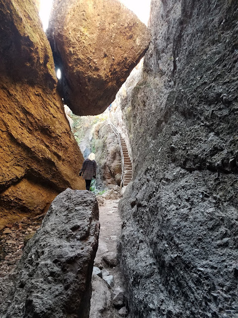
Into the Bear Gulch Caves (bring a flashlight if you go)
Pinnacles National Park is a fascinating place to visit for many reasons. It was once a stratovolcano (composite cone) composed of andesite, dacite, and rhyolite standing perhaps 8,000 feet above sea level. It had at least five eruptive centers, which would have given it a less symmetrical profile than peaks such as Fujiyama or Mt. Hood. Perhaps a good analog that can be visited today would be the lumpy edifice of Mammoth Mountain, that of the famous ski area in the eastern Sierra Nevada.
At the top of the Bear Gulch Caves, just below the reservoir
The volcanic rocks are fairly resistant to erosion, but are riddled with joints and fractures that allow water (and sometimes ice) to get in and weather the minerals to clay. Mass wasting does much of the rest, causing gigantic boulders to slide, tumble and fall into the adjacent valleys. In some cases the boulders were so thick that they covered the bottom of the canyon, forming some fascinating talus caves. We explored the Bear Gulch Caves during our recent field studies to the park. The CCC built a trail and stairway through the cave, leading to an experience akin to the Fellowship of the Ring exploring the Mines of Moria. There is even a modest underground waterfall. At the end of the caves, one more stairwell climbs the rock wall to the modest Bear Gulch Reservoir, also built by the CCC. 
There are miles of other trails in the park, including the High Peaks Trail that must not be missed as long as your phobia of heights is held in check. It is a marvelous 5 mile loop that provides awesome views. Other trails explore the sycamore woodlands along the streams. There are several visitor centers and a campground. If you pay close attention, you will see California Condors soaring in the skies above.
In case you are wondering, the Neenach Volcanics are not nearly as dramatic as Pinnacles. They are exposed at the edge of the Mojave Desert relatively close to the Antelope Valley Poppy Preserve. I stopped there a few years back and got a couple of pictures and some rock samples. It's kind of neat to pull out the tray of Neenach Volcanics samples during our field trip and do a visual comparison with the Pinnacles rocks. We end up bringing the sundered volcano back together in a small way...


Hill, M.L., and Dibblee, T.W., Jr., 1953, San Andreas, Garlock, and Big Pine faults, California: Geological Society of America Bulletin, v. 64, p. 443–458.

Matthews, V., III, 1976, Correlation of Pinnacles and Neenach volcanic formations and their bearing on San Andreas fault problem: Bulletin of the American Association of Petroleum Geologists, v. 60, no. 12, p. 2128-2141.

Sunday, November 19, 2017

An Iconic Bit of the Calaveras Fault in Hollister is Gone (But it will be back)

Corner of Locust and Central Avenues in 2016
I go on field studies trips year after year, and my camera is always around my neck, to the amusement of my students. They sometimes wonder why I would take pictures of things I already have dozens of pictures already. I sometimes wonder the same thing when I am trying to track down a specific shot from my archives of tens of thousands of pictures. But for a teaching geologist, there is a very good reason:

Things change.

Sometimes it is sudden, like a flood in Yosemite or on the Tuolumne River that actually alters the look of a landscape. It's nice to be able to catalog before-and-after views of a place. But in others, it is because of the incremental geologic changes. That's especially true with a couple of faults in Central California, the San Andreas and the Calaveras.
Corner of Locust and Central Avenues in 2013
Yesterday I updated the spot on Highway 25 near Pinnacles National Park where the San Andreas fault crosses the road (and I deeply appreciate the widespread response, especially on Twitter). The spot visibly changes every year. For decades, geologists have also been tracking the creeping of the Calaveras Fault in downtown Hollister. Generations of geology class field trips have walked several city blocks, tracking the fault as it offsets streets, sidewalks, curbs...and houses! I hope that all who do so remember to stay on sidewalks and not become nuisances to the residents. They have enough to contend with when you think about it.
The corner of Locust and Central Avenues in 2001

One curb has been iconic; it's been an illustration in any number of textbooks and PowerPoint presentations. The corner of Locust and Central Avenues is offset by the Calaveras Fault adjacent to the crosswalk, so it can be observed easily without bothering residents. It's one of the most vivid examples of right lateral offset imaginable, and if one knows the age of the sidewalk, the changes can be used to calculate the yearly rate of movement on the fault. The break is not a perfect measure because the deformation is spread out for several yards on both sides of the break (note how the sidewalk is curved in the pictures above).

So you can imagine my surprise on Saturday to find that the iconic curb disappeared sometime last year. It was for a good reason, as the city put in a wheelchair ramp, but it was still a shock. I was disappointed for a moment for my students until I realized that for the first time in 15 years, we have a brand new baseline of fault movement. Because as surely as the curb was offset before, it will continue into the future. We'll be watching for the first of the tensional cracks in the concrete, eventually to be followed by total rupture and offset curbs.
Corner of Locust and Central in 2017
Geology never stops.

Saturday, November 18, 2017

Why did the Road Cross the San Andreas Fault? 15 Years of Geologic Change (an Update)

2002
I've been leading geology field studies trips to lots of places in the American West for 29 years and started to take digital pictures in 2001. I sometimes struggle to find new things to photograph when I visit a place for the 29th time, but in some cases it is not a problem. There are geologic changes that happen on a yearly basis, and with fifteen years of photos, the changes become obvious. This is a continuing update from a post in 2013, and I'll probably continue updating for the foreseeable future.
2004
Highway 25 in the California Coast Ranges connects the town of Hollister with the access road to Pinnacles National Park (formerly Pinnacles National Monument). Along the way the highway crosses the San Andreas fault in a section where the fault creeps an inch or so each year (36°35'54.27"N, 121°11'40.19"W). Most years we've stopped to have a look at the effect the movement has on the pavement. In 2002 and 2004, the damage was obvious.
2008
By 2008 someone had patched the road, and no fault motion was evident.
2009
Little damage was evident in 2009 either. But by 2010 cracks had begun to appear as the fault stressed the pavement.
2010
The fact that the fault creeps in this region is a good thing. It means that stress is not building along the fault surface, but instead is being released gradually. The sections of the fault to the north and south of the creeping section are locked by friction, and are building up the ominous stress that will eventually produce quakes with magnitudes in the range of 7.5 to 8.0. The quakes are coming and we need to be as prepared as possible.
2012
By 2012, the road had been completely repaved, and  yet the shearing was already evident.
2013
It became even more pronounced by 2013 and in 2014. Just by chance, the person working as a scale was the same individual as in 2004.
2014

In 2015 the fractures were moderately larger. They'll need to start thinking of road repairs before long.
2015
In 2016 Laura once again provided scale, as she did in 2014, and 2004.
2016
Here in 2017, long-time trip volunteer Mary provides scale. The cracks in the road are just a bit larger, but they didn't look appreciably different than the previous year except for a twist (pun intended)...
2017
The paint on the road was obviously offset, a lot more than last year. Even more interesting is the despite the offset, the paint was deformed (twisted), not split.
The offset paint strip reminds me of illustrations of elastic rebound theory, the idea that stress builds up on a fault line over time. In that model, the land on either side of the fault is distorted over time until the frictional resistance is overcome and the rock snaps back to its original shape. That won't be happening with the paint, but if they don't repair the road (as they often do; see above), it will probably show a clear break by next year.

The other "twist" is that a magnitude 4.6 earthquake took place last week less than two miles from the road crossing. It probably did little to change things on the road exposure, but serves as a reminder of the need to not be complacent about the existence of this fault in our state.

These little changes that happen at a rate visible in human lifetimes add up to huge changes when multiplied by thousands or millions of years. The nearby eroded volcano of Pinnacles National Park has been displaced 195 miles (315 kilometers) in the last 20 million years or so by movement along the San Andreas.
Until next year!

Thursday, November 16, 2017

Aerial Geology: A High Altitude Tour of North America's Spectacular Volcanoes, Canyons, Glaciers, Lakes, Craters, and Peaks. A Book Review...

A most interesting book landed on my desk recently. Timber Press asked me if I was interested in reviewing Mary Caperton Morton's book Aerial Geology, A High Altitude Tour of North America's Spectacular Volcanoes, Canyons, Glaciers, Lakes, Craters, and Peaks. I am most pleased to do so, but a bit of explanation is necessary to explain why.

If you have been following my blog from early on (the very ancient days of January 2008), you will know that I am thrilled by plane rides, and the unique perspective that aerial photographs add to one's understanding of geology. I didn't get to fly much as a child and teen, but I lived in southern California, and I was surrounded by high mountains: the San Gabriel and San Bernardino Mountains were only a short drive away, the Sierra Nevada and the Mojave Desert just a little farther. My favorite weekends were those spent climbing mountains that gave me a view. If I was stuck at home, I climbed to the very top of a deodar tree in my backyard that gave me a look at the surrounding neighborhood (I thought as a child that it must have been 50 feet high, it was more like 20...). When I took my first geology class in 1975, I was introduced to the perfect book that would feed my mania for high places: Geology Illustrated by John Shelton, published in 1966. Ostensibly it was a basic physical geology text, but it was illustrated with a stunning set of aerial photographs taken by the author. His book, despite being out of print for decades, is considered one of the 100 most influential books in science for the last century by American Scientist. A great many of the photos were of places I was familiar with, and so I treasured the book. My copy is barely holding together, but I still refer to it once in a while.

So why am I talking about one book when I am supposedly reviewing another? It's because some things have changed in fifty years. In 1966, we had barely been to space, much less seen the Earth in high quality photographs. The iconic Blue Planet photograph, taken by the astronauts of Apollo 17 was still six years in the future. A furious debate was taking place in the geological community about the strange concepts of continental drift and plate tectonics. It was only just beginning to be acknowledged by some geologists, but full acceptance was still a half decade away. Our knowledge base on all manner of geological processes has expanded astronomically. Our access to scientific knowledge has left the dusty halls of libraries and landed in our pockets through the internet and smart phones (this statement is not to be taken as a slam on libraries, which still provide so much good in our communities). And perhaps above all, our use and abuse of the resources of our planet has threatened to upset the delicate web that keeps our civilization intact: global warming, soil depletion, groundwater use, and so many other issues are affecting our daily lives. Just ask the people of Houston, Puerto Rico, California's Wine Country, and so many others who have been affected by intense geological and climatological processes.
Mississippi River Delta, a NASA image from Aerial Geology

There is still a vast dearth of scientific literacy in our society, especially when it comes to geologic processes. The internet can do much good, but it also is a source of bad information and stupid conspiracies. Wouldn't it be nice if there was an accessible and attractive book that could lay out the basics of geological processes accompanied by spectacular views that take in advances in satellite technology as well as beautiful old-school aerial photographs?

Yes it would, and that's why I can highly recommend Aerial Geology. Mary Morton has selected 100 significant sites and locales in North America that illustrate geological processes in action. Many of the sites chosen are familiar and expected locales, but there are also quite a few that are less known. Each site has a well-written vignette that outlines the basic geology and occasionally related environmental problems. The pages for the Mississippi Delta (above), for instance, describe the very serious problem of subsidence: the delta is disappearing into the Gulf of Mexico at the rate of a football field per hour.
NASA image of Craters of the Moon in Idaho, from Aerial Geology
People who fly often may find their interested in the world below rejuvenated by reading this book. A helpful feature is a notation on each vignette that explains what commercial flights may reveal the feature in question (even when I'm paying attention, I can get lost at 35,000 feet and not know what spot I'm looking at).

Aerial Geology is well-written and beautifully illustrated, and is a worthy successor to Shelton's Geology Illustrated. I enjoyed learning about some new places, and finding out new things and new angles on many familiar places as well. The author is a frequent contributor to Earth Magazine, and has an excellent blog on geological topics as well. The book is available at the usual places, including the publishers website and Amazon (and it is surprisingly inexpensive if you are looking for a cool Christmas gift). Check it out!

Disclosure: I was provided with a review copy of the book.

Sunday, November 12, 2017

A Landscape as Bizarre as They Come: The Volcanic Tableland of the Eastern Sierra Nevada

The Volcanic Tableland, with the White Mountains beyond.
There is a bizarre landscape on the far side of the Sierra Nevada between Bishop and Mammoth Lakes. It's not one of stark beauty exactly, it's barren and covered by little more than sagebrush. It's got few roads or trails, primarily because very little of this landscape is of much use to anybody. From above, the surface is riddled with scarps and grabens from numerous faults. This is a broken-up land. It's not...normal.
Source: US Geological Survey
The surface of this landscape isn't "right" either. There are no dark rich soils here. The underlying rock is pink or white, and so is the weathered soil and debris that covers it. Although the surface has an area of several hundred square miles or more, the underlying rock is remarkably uniform. It is a volcanic rock called rhyolite tuff. And with that name, the explanation for this landscape is revealed: it is the remnant of an ancient disaster beyond imagining.
767,000 years ago, an explosion took about 125 cubic miles of pasty magma from the crust and blew it into the atmosphere. The huge void collapsed inwards, forming an oval-shaped depression 20 miles long, 10 miles wide, and a mile or more in depth. The resulting ash spread far and wide, blanketing the western United States. Measureable deposits can be found in Kansas and Nebraska. But most of the ash came straight down. Some of it refilled the caldera, but much of the remainder buried the regional landscape hundreds of feet deep in hot ash. All life would have been extinguished for miles in every direction.

It is difficult to understand the magnitude of such events. From a human perspective, we have nothing to compare it to. An eruption at Tambora in Indonesia in 1815 produced less than a tenth of the ash as Long Valley, and that was enough to cause global cooling with related summer snowfall, crop failures, and famine across the northern hemisphere. The effects of an eruption the size of Long Valley on modern civilization would be appalling. I've heard it said that modern agricultural production has a month-long lead on consumption demand (No, I can't cite a source. It's a factoid I'm sure I heard or read somewhere). Try to imagine a disruption of agricultural production lasting several years. Governmental and societal structures would collapse, and the death toll would be unimaginable. Humans would no doubt survive, but it would be a dystopian landscape as bad as any sci-fi action movie, and maybe worse.

The only good thing that I can think of to say on this possibility is that studies of calderas like Long Valley or Yellowstone suggest that the eruptions will be predictable on a scale of decades or centuries. There would be time to prepare the eruption, or, however unlikely, geo-engineer the caldera to lessen the intensity and effect of the cataclysm.

What happens when a singular event completely reshapes a landscape? The eruption of Long Valley completely disrupted the drainage patterns of the eastern Sierra Nevada and Owens Valley. The land had to start over. Where there had once been river valleys and canyons, there was now a gaping pit miles wide and long. The evidence suggests that for 600,000 years the caldera depression contained a huge lake similar in plan if not in scale to Crater Lake. Crater Lake has no outlet, with the lake level determined by evaporation and seepage. The Long Valley Lake would have been similar, as no evidence exists for an outlet, at least until around 150,000 years ago.
Source: U.S. Geological Survey

For 600,000 years sediment washed into the basin, slowly filling it. Finally, along the south rim of the caldera near the present day site of Crowley Lake, the basin spilled over. In just 150,000-160,000 years, the Owens River carved a 400-500 foot deep gorge down the surface of the Volcanic Tableland, laying bare the full extent and history of the climactic eruption of the caldera. The rate averages out to about a foot every 400 years, but the rate was probably higher at the beginning. The small creek that flows through the gorge today is a mere shadow of its former self. The Los Angeles Department of Water and Power has co-opted most of the water, but a court order several years ago mandated that a minimum flow must be maintained.
Because the LADWP has utilized the water from the Mono Lake Basin to the north, they have constructed penstocks and pipelines that allow them to produce energy as they transport water down the long slope of the Tablelands. That means access roads, and it is thus easy to visit the gorge, and it is fascinating.
The mounds seen occasionally along the rim are the eroded remnants of fumaroles, where steam would have emanated from the interior of the ashflow, leaving mineral deposits that toughened the rock. The tuff at the rim is relatively soft, but as one walks deeper into the gorge, the rock becomes harder (it tuffons up?). When the hot ash landed, it was hot enough to remelt, forming welded tuff, or ignimbrite. Pieces of pumice caught up in the eruption became flattened and smeared in places.
As the rock cooled, it contracted to form columnar joints. Unlike Devils Postpile, a few miles away on the other side of the crest of the Sierra Nevada, these columns are not vertical. Most columnar jointing is not. The intense fracturing of the rock into these columns aided the Owens River in the carving of the gorge, as the crumbling rock could be quarried by the rushing water much more readily than solid rock.

The columns average six sides, but columns with 4, 5, or 7 sides are occasionally seen.
The Volcanic Tableland and the Owens Gorge are otherworldly, but they provide a hint of how quickly landscapes can adjust to new geological conditions. It took 600,000 years to fill a basin 10 by 20 miles with at least 2,000 feet of sediment, and 150,000 years to carve a 400 foot deep gorge. This is fast by geologic standards, but humans, had they been around this region at the time, would not have noticed much change in course of their lifetimes. Just like we aren't noticing the changes now...