Access is the death-knell to Ancestral Puebloan ruins. The closer they are to roads, the more likely they are to be destroyed by pothunters and vandals (both of whom are the lowest of human beings). To see these wonderful ruins, we had to walk a total of eight miles, and that doesn't count the required climbing to approach the ruins themselves. There was only a trail of use to follow.
The trail began in a shallow canyon with an ephemeral stream. After a mile or so, the canyon deepened, and the first of the ruins appeared (above). It just goes to show how I can miss significant sights sometimes, by realizing that the ruin above is famous, and is found in posters and art exhibits. It's called the House on Fire Ruin (or some variant), and I totally missed the effect of the crossbedded Cedar Mesa Sandstone that flares out above the dwelling. Check out this page (or this one) for an example of a shot taken with a photographer's eye
The ruins in the canyon (there are eight or so of them spread over three miles) are in surprisingly nice condition, with intact walls, doorways and ceilings.
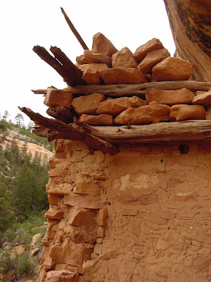
The dwelling in the pictures above and below even has an intact stairwell. This particular ruin is relatively inaccessible; people can get to it, but it requires a somewhat vertiginous crawl up some precariously perched logs on an 8 or 10 foot overhang. I haven't managed it yet in two tries (because I knew I had to get back down, and wasn't sure of myself).
Some of the alcoves don't have dwellings (anymore) but they do have pictographs, including the hand prints below. These messages communicate to me the humanity of a single individual who lived in this place 700+ years ago.
There are also ghostly dancing figures...
I talked in previous posts of the frustration of having ruins that have been stabilized and "cleaned up". One starts to lose that sense of personal discovery (my so-called Indiana Jones effect; it's addictive and not really good archaeology). Of course it makes sense that a park with high visitation would never leave artifacts out in plain sight. They would disappear quickly. Here, miles from the end of the road, people have decently left things in place for others to see.
The remnants of some kind of woven yucca fibers, a moccasin maybe?
Corncobs, minus the corn (rodents are very active in these ruins). The Ancestral Puebloans subsisted on maize, beans and squash, with the occasional supplementary meat provided by rabbits, deer, and bighorn sheep.
The upper canyon held what was to me one of the most fascinating dwellings I've run across (below). It's in a side canyon choked with willows and brush. Except for the fact that I knew a dwelling was up there somewhere, I never would have fought my way through the brush, but I did, and I almost missed the ruins anyway. The logs sticking out of the sheer cliff (and the small dark openings) were my only clue. I got the impression these people did not want to be found...
As we drew closer, more walls appeared, molded seamlessly into the vertical cliff. The walls hid a series of small alcoves into which rooms had been constructed. Instead of a single room perched on a block of rock, this was a small pueblo complex with at least seven or eight rooms. The upper log sticking out of the cliff was probably the brace for a ladder that accessed the rooms even higher up the cliff.
We shimmied up the log to access the pueblo, and were surprised by how much space was present behind the outer wall.
The walls and doorways were remarkably well preserved. The lintels over the doors were still encased in the adobe, and in many places, the fingerprints of the builders were preserved.
The logs forming the ceilings were unchanged, except for generations of cooking fires.
Roof intact, plaster coverings intact, wood unburnt...this was one of the best-preserved pueblos I've ever seen.
The dwelling is referred to as the Wall Ruin, and it is 3.7 miles up the canyon. You may notice I'm not making a big issue about where the dwellings are located, but there are enough clues here to figure it out on the internets with a bit of searching. I want this place to be here 700 years from now, and even though these sites are legally protected, any idiot can destroy centuries of culture in a matter of minutes. I've even heard of morons who used wood beams from 700 years ago...as firewood.
I like to think that spirits of the ancestors still inhabit these places, and I like to think that they will make life miserable for those who abuse and vandalize their realm.
The next portion of our journey would take us into a different landscape, one that was largely ignored by the Ancestral Pueblo people, a place where it was too dry to grow crops and subsist off the land. We were headed into the Canyonlands.
Meanwhile, in the present day, I will be on the road for a few days, taking our students on a field studies excursion into the eastern Sierra Nevada and Owens Valley. See ya'll in a few days!


2 comments:
Garry, Fun photos. Cedar Mesa is indeed a splendid place. I especially like the shot of the corn, certainly one of the most direct connections one can make to those who came before.
Cheers,
David
Simply glorious - I'm glad you scrambled up to those wonderful places. Although I have cramped stomach muscles looking at the photos (hate heights!). Thanks for posting this important site and the photos, as well.
Post a Comment